3300 Lower Lock Avenue
Belmont, California, USA 94002
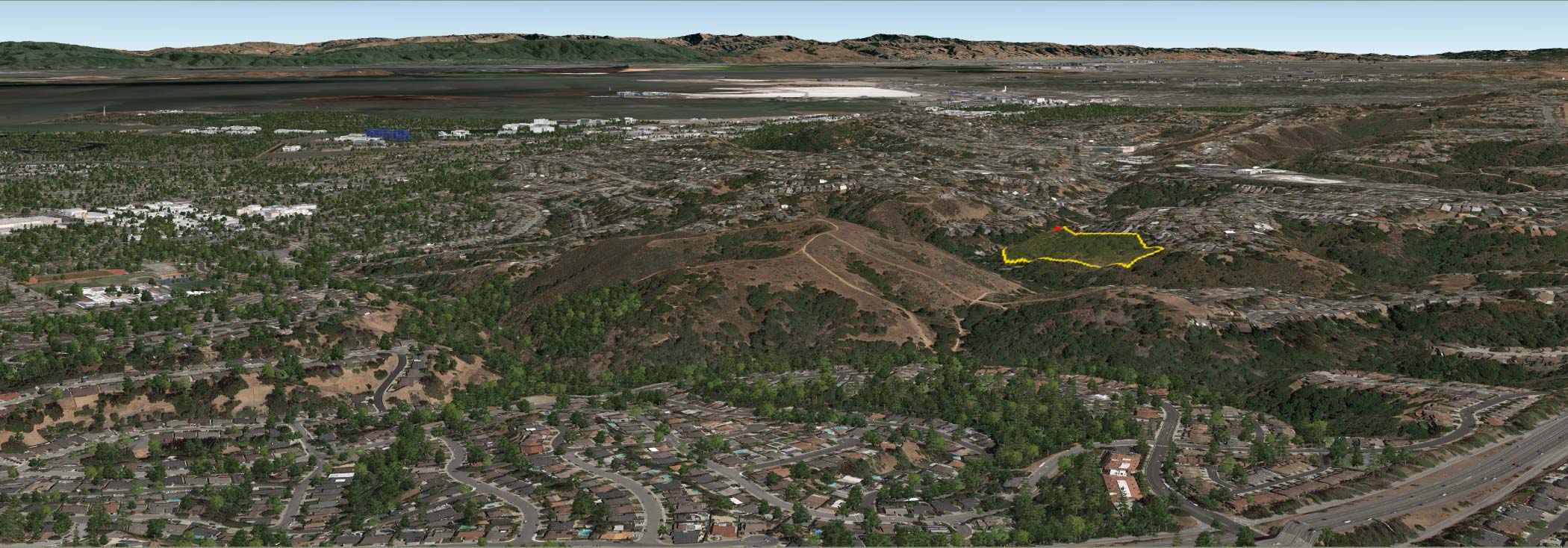
The Preserve (outlined in yellow and only partly seen in this view) is surrounded by public and de facto private open space. The lines through undeveloped areas on Sugarloaf Mountain (seen to the left of the Preserve) and toward the right foreground are trail networks. Yet it’s just 3 minutes to Route 92, 5 minutes to I-280, and 8 minutes to US 101. It’s 14 miles to Sand Hill Road in Menlo Park and 26 miles to downtown San Francisco.
The homesite itself (shown in red above) is a knoll on a ridge. The forested Preserve extends well below and to both sides of the house, so you will never have neighbors on three sides. In fact, when looking toward the Bay, the nearest homes you can see are over 600 feet away. No homes are visible looking toward Sugarloaf. Open space preservation guarantees your views and privacy: no more homes can be built in your sweeping views or above your home.
Times & Distances
-
Route 92 (nearest freeway) 3 minutes
-
I-280 5 minutes
-
US 101 8 minutes
-
Sand Hill Road, Menlo Park 14 miles (21 km)
-
Downtown San Francisco 26 miles (40 km)
-
Half Moon Bay 10 miles (17 km)
-
Public Schools
-
Fox Elementary School K-5 4 minutes | 1 mile
-
Ralston Middle School 6,7,8 4 min | 1.7 mi
-
Ralston Intermediate School 6,7,8 2 min | 0.5 mi
-
Carlmont High School 9-12 5 min | 2.0 mi
-
Private Schools
-
Serendipity School PK-5 5 min | 1.3 mi
-
Belmont Oaks Academy K-5 5 min | 1.8 mi
-
Gloria Dei Lutheran Elementary K-8 2 min | 0.7 mi
-
Immaculate Heart of Mary School K-8 4 min | 1.6 mi
-
Notre Dame High School 1-8 6 min | 2.3 mi
-
Colleges
-
Notre Dame de Namur University 6 min | 2.3 mi
-
College of San Mateo 7 min | 3.0 mi
-
Stanford University 22 min | 14.7 mi
-
Shopping
-
Crystal Springs Shopping Center 4 min | 1.9 mi
-
Carlmont Village Shopping Center 4 min | 1.7 mi
-
Laurelwood Shopping Center 6 min | 2.8 mi
-
Hospitals
-
Sequoia Hospital 13 min | 5.2 mi
-
Mills Peninsula Hospital 15 min | 9.7 mi
-
Stanford Hospital 21 min | 14.7 mi
-
Airports
-
San Francisico International Airport 19 min | 13.5 mi
-
San Jose International Airport 36 min | 26.5 mi
-
Public Transportation
-
Caltrans 8 min | 2.9 mi
-
…to downtown Palo Alto 17 min
-
…to downtown San Francisco 36 min
-
Private Golf and Country Clubs
-
Peninsula Golf and Country Club 8 min | 4.3 mi
-
Burlingame Country Club 14 min | 7.7 mi
-
Green Hills Country Club 17 min | 10.0 mi
-
California Golf Club of San Francisco 18 min | 13.5 mi
-
Stanford University Golf Course 21 min | 14.2 mi
-
Sharon Heights Golf and Country Club 23 min | 14.5 mi
-
Palo Alto Hills Golf and Country Club 23 min | 17.1 mi
-
Public Golf Courses
-
Poplar Creek Golf Course 8 min | 2.9 mi
-
Crystal Springs Golf Club 10 min | 5.4 mi
-
Mariners Point Golf Links 14 min | 7.7 mi
-
Parks
-
Water Dog Lake Park 7 min | 2.0 mi
-
Laurelwood Park 6 min | 2.4 mi
-
Sawyer Camp Recreation Trail 11 min | 4.0 mi